3.4 Energy and Environment

What is the solar potential of buildings at city-scale?

City-scale evaluation of buildings’ PV potential is essential to target efforts. Here, we show how accounting for vegetation and weather variability highly affects the results of the evaluation.

This sheet presents a tool for mapping the energy potential of existing buildings in urban areas under uncertain environmental conditions. Indicators are based on the simulated hourly energy production of PV modules and energy demand of buildings. Multiple modeling scenarios give the confidence bounds of the simulated energy potential, and different spatial aggregation scales convey relevant information to decision-makers. The results are expressed in a solar score giving a robust ranking of the performance of each spatial location.
 
Keywords: Simulation-based urban energy planning; Decision support; 3D city models.
Target audience: Regulation makers; Owners & other decision makers.

Fig. 1 Visualization of the 3D city model (City of Neuchâtel, Switzerland) [2].

Solar cadastres, or solar maps, are tools to provide decision-makers with information about the suit-ability of a given building surface for the installation of solar power systems, such as photovoltaic or solar thermal. There is currently a gap between detailed simulation tools for single solar installations and those used in large-scale analyses, such as solar cadastres. The latter are usually based on sim-plified solar radiation tools and provide time-cumulated results and up to the building surface.

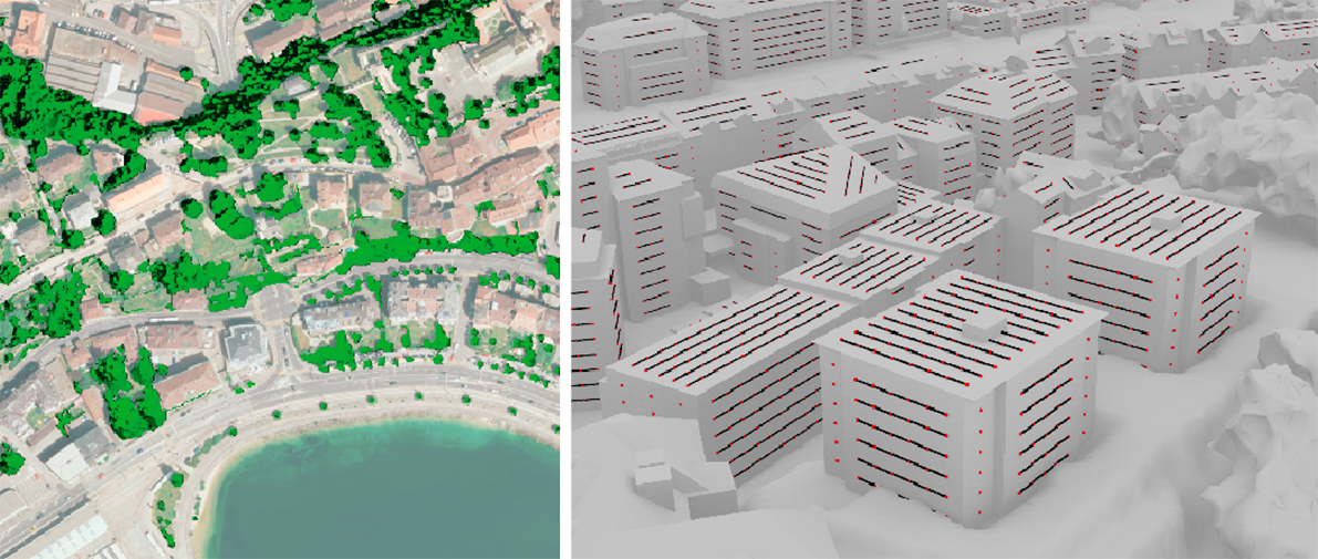
This work aimed at pushing the boundaries of the analysis in terms of granularity, using state-of-the-art solar radiation and PV performance models, advanced 3D geo-data and weather measurements recorded over lengthy periods of time. In particular, the developed simulation workflow took ad-vantage of the high-resolution 3D point clouds from airborne laser scanning and 3D city models that are widely available in Switzerland, through the Confederation and many cantons.

This proposed workflow also integrates climate-based dynamic simulation of building energy demand showing the potential for energy retrofit of the building thermal envelope. We argue that, in fact, BIPV installations complement building energy retrofit interventions ideally. Moreover, simulation of the hourly energy demand allows for sizing the solar installation based on building self-consumption, as encouraged by the new Federal Energy Act.
 
In existing urban-scale solar assessment methods, the decision support is usually neglected or is associated to simplified modeling tools or input data. This work instead couples the advanced simulation method presented above in an innovative planning-support system [1,2,3], aimed at comparing the building’s energy potential under uncertain environmental conditions through risk-averse scenarios. The method also accounts for some crucial uncertainty factors (vegetation and weather), so as to provide robust decisions based on multiple modeled scenarios.
Fig. 2 Visualization of the 3D city model (City of Neuchâtel, Switzerland) [2].

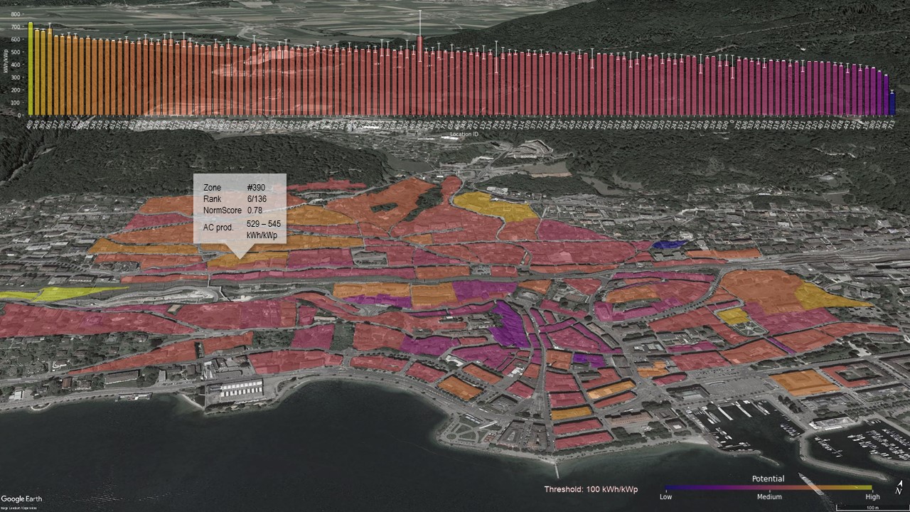
An interactive 3D map indicates the priority level of energy refurbishments and/or PV installations in buildings at different spatial aggregation scales (e.g. building surface, building, urban block) expressed as a solar score. It is then possible to easily detect which spatial locations would benefit most from a solar installation and a retrofit intervention. This could help local authorities to target investments where they are most needed, as well as large building owners to prioritize the refurbishment of their building stock.

References

[1] G. Peronato, P. Rastogi, E. Rey, M. Andersen. “A toolkit for multi-scale mapping of the solar energy-generation potential of buildings in urban environments under uncertainty”. Solar Energy, vol. 173, 861–874, 2018. https://doi.org/10.1016/j.solener.2018.08.017
[2] G. Peronato, M. Andersen (Dir.), E. Rey (Dir.). “Urban planning support based on the photovoltaic potential of buildings: a multi-scenario ranking system”. EPFL Thesis n°9051, 2019.
[3] G. Peronato, E. Rey, M. Andersen. “3D model discretization in assessing urban solar potential: the effect of grid spacing on predicted solar irradiation”. Solar Energy vol. 176, 334-349, 2018.
 
Contact person
Sophie Lufkin | EPFL-LAST | sophie.lufkin@epfl.ch

PDF